As a teenager I hated walking. Urrgh! Wossa point?
My lifelong love affair with the paths and byways of Britain really only began as a young man some 50 years ago on long-distance walks with my father John. I learned to see further than the end of my self-obsessed nose, and to enjoy finding out about wild birds, flowers, trees and rocks, and the vivid stories that underlay old lead mines, fishing ports and stone circles. When I found I could make a better and more enjoyable living as a walking writer than as a reluctant teacher – bingo! – I was out of the classroom and into the fields with pen, notebook and map. I’ve never been the strongest or most knowledgeable walker. But I do love wandering the shores and hills of these wonderful and enormously varied islands of ours, and trying to entice other people to enjoy them too. So here are 18 of my favourites from hundreds of walks I’ve taken – and I’ve written dozens of walking books, so I ought to have worked out which ones I like best by now.
Each one is tried and tested, from the Cornish coast to the Yorkshire Dales, the gentle field paths of the Midlands to the rugged high country of Scotland, Wales and Northern Ireland.
They’re all great for autumn, with a cosy pub waiting at the end. What more could you want?
St Ives and Zennor, Cornwall
I rate this the finest stretch of cliff scenery in western Cornwall. You plunge into stream valleys and miniature coves, climbing again across rugged headlands where peregrines hunt.
When you get to Zennor and the Tinners Arms, pop across the road to visit the 600-year-old Zennor Mermaid, carved on a chair-end in St Senara’s Church. The field path back to St Ives is an ancient corpse road along which dead people from far-flung farms would be carried in their coffins for burial in the town.
Distance: 11 miles.
Start: St Ives station, or Barnoon car park, TR26 1JF (OS ref SW 516 406).
Rating: Moderate.
Pub at the end: The Sloop Inn dates from 1312 and has low beams and hidden snugs, down on the wharf – plus great seafood chowder (sloop-inn.co.uk).
Postbridge and Bellever Tor, Dartmoor, Devon
Postbridge lies at the centre of Dartmoor’s wild moorland. From the medieval clapper bridge over the East Dart River, a bridle path runs south across the moor by way of Bellever village and the intriguingly named Laughter Hole Farm to reach the Laughter Man standing stone, 10 ft tall.
Cross Bellever Tor with its grazing ponies and piles of wind-sculpted rocks, and take the rough path back towards Postbridge. On Lakehead Hill you’ll pass stone circles and cist burial sites, memorials of our ancient ancestors.
Distance: 5¾ miles.
Start: Bellever Forest car park, Postbridge PL20 6TH (OS ref SX 647 786).
Rating: Moderate.
Pub at the end: Expect a blazing fire and top-notch home-made pies at the nearby Warren House Inn (warrenhouseinn.co.uk).
Chichester and West Wittering, West Sussex
This walk beside the great tidal inlet of Chichester Harbour follows the quiet waters of Chichester Ship Canal as far as Chichester Marina.
From here you shadow the muddy, bird-haunted shoreline, passing West Itchenor with its boatyard and cosy The Ship Inn. On along the shore, with sailing boats scudding by. Beyond the sandy dunespit of East Head lie West Wittering’s famed sands and the distant Isle of Wight.
Distance: 12 miles (7 miles to West Itchenor).
Start: Chichester station, PO19 8DL (OS ref SU 859 043).
Rating: Easy but long.
Pub at the end: The Wittering pub has a nice fireplace and serves seafoood, steaks and vegan dishes (thewittering.com).
Wayland’s Smithy and Uffington White Horse
In Oxfordshire, from the Vale of White Horse you climb to the ancient Ridgeway track, passing two extraordinary monuments.
First is Wayland’s Smithy, a Neolithic burial chamber in a ring of beech trees. Legend says it’s the forge of Wayland, lame blacksmith of the Viking gods. A mile away along the Ridgeway, the 3,000-year-old Uffington White Horse springs in chalky curves across the downland. From here you descend via Britchcombe Farm to Woolstone and the White Horse Inn.
Distance: 8 miles.
Start: White Horse Inn, Woolstone, Faringdon, Oxfordshire SN7 7QL (OS ref SU 293 878).
Rating: Easy.
Pub at the end: The White Horse is a distinguished half-timbered pub with a fireplace and lots of nooks and crannies (whitehorsewoolstone.co.uk).
Latimer, Chenies and the Chess Valley
From Chalfont & Latimer Tube station, in Buckinghamshire, you walk north into West Wood, where the Chess Valley Walk trail descends to cross the River Chess near the estate village of Latimer.
From here, it’s a clockwise circuit, following the green and gorgeous Chess Valley with its shallow, winding river to Church End and the astonishing 14th-century paintings in the village church.
The Chiltern Way leads back through woods of hornbeam and cherry to Chenies village and its great Tudor mansion of Chenies Manor where King Henry VIII still walks at night, a limping ghost.
Distance: 7 miles.
Start: Chalfont & Latimer tube station, Bucks, HP7 9PR (OS ref SU 99605 97550).
Rating: Easy.
Pub at the end: Round the corner from the station, the Metropolitan serves pizzas and burgers (themetropolitanlc.co.uk).
Grantchester and Cambridge
Cambridge University undergraduate and poet Rupert Brooke came in 1909 to lodge in the nearby village of Grantchester, revelling in its ‘lovely and dim and rustic life’. That phrase of Brooke’s resonates in sleepy Grantchester and along the footpath through the meadows of the River Cam where undergraduates still lounge, bathe and punt beneath the willows. Arriving in Cambridge, paths and lanes keep close by the Cam. At Midsummer Common, head across the meadow to the city centre and bus station for the No 18 to Grantchester.
Distance: 4½ miles.
Start: Grantchester village car park, Grantchester Road, CB3 9NB (OS ref TL 433 553).
Rating: Easy.
Pub at the end: The old-fashioned Clarendon Arms, near Cambridge bus station, does roasts (instagram.com/theclarendonarms).
Hunstanton and Holme Dunes, North Norfolk
Walking east from Hunstanton along the dusky red sands you pass cliffs striped dramatically in red and white.
From Old Hunstanton the coast path runs through Holme Dunes, a line of sandhills with a grassy hinterland, both spattered with wild flowers – blue sea holly, yellow stonecrop, marsh orchids.
Beyond Holme Dunes the path turns inland to reach Thornham village, the Orange Tree pub, and the Hunstanton bus.
Distance: 6½ miles.
Start: Hunstanton seafront, PE36 5BQ (OS ref TF 672 409).
Finish: The Orange Tree, Thornham PE36 6LY (TF733 432). Norfolk Coastliner bus back to Hunstanton.
Rating: Easy.
Pub at the end: The popular little, family-owned Orange Tree pub has a burning fire and good menu; best to book a table (theorangetreethornham.co.uk).
Stiperstones, Shropshire
The quartzite outcrops of the Stiperstones stand at the north-west end of the Long Mynd, Shropshire’s great whaleback of a hill. These jagged spires of rock rise from an upland heath where the view runs from Wenlock Edge round to the Welsh Border hills. A side path dips steeply downhill past old lead-mine workings to Stiperstones village far below. From here a lower track leads back below the Stones, standing dominant along the eastern skyline.
Distance: 5 miles.
Start: Bog Visitor Centre car park, Stiperstones, Shrewsbury SY5 0NG (OS ref SO 355 979).
Rating: Moderate.
Pub at the end: The Stiperstones Inn is a lovely traditional pub with a roaring fire; steaks, burgers and good vegetarian options on the menu (stiperstonesinn.co.uk).
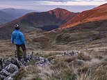
Arenig Fawr, North Wales
From the bothy beside Llyn Arenig Fawr you climb the steep slope. A couple of fences to hop, a boggy upland to cross; then loose screes and rocky steps to the summit of Arenig Fawr at 2,802 ft/852 m. Mountains stand all round – Clwydian Hills and Berwyns to the east, Cadair Idris hunchbacked in the southwest, and to the north-west Eryri/Snowdon itself.
Distance: 7¼ miles out and back.
Start: Parking space opposite gate signed ‘Farmland’, about a mile east of Arenig, near Bala; at post code LL23 7PA, approximately (OS ref SH 846 395).
Rating: Hard mountain hike including a 1,720 ft/530 m climb.
Pub at the end: None in the immediate vicinity, but it’s a short-ish drive to the brilliant, down-to-earth White Lion community pub in Cerrigydrudion (gwestyllewgwyn.uk).
Kinder Edge, Peak District, Derbyshire
This superb walk follows the outward route of the ‘Mass Trespass’ of 1932, youngsters from Manchester determined to assert their right to roam across the Peak District.
Up beside the beck in rocky William Clough to Ashop Head. An exhilarating stride along the magnificent gritstone outcrops of Kinder Edge, with tremendous views over Manchester to the hills of North Wales; then the long lane from ancient Edale Cross to Bowden Bridge.
Distance: 8½ miles.
Start: Bowden Bridge car park, 165 Kinder Road, High Peak, SK22 2LJ (OS ref SK 048 869).
Rating: Hard.
Pub at the end: The friendly Sportsman Inn is a short stroll from the car park with good food (thesportsmaninn.co.uk).
Wharfedale and Littondale, North Yorkshire
From Kettlewell you climb steeply up Gate Cote Scar. The path threads across Middlesmoor Pasture before descending via Park Scar into Littondale and the Falcon Inn on Arncliffe’s village green.
An old cart track runs by Brayshaw Scar and Old Cote Moor among milkwort, lady’s bedstraw, wild thyme and rockrose. Down into Wharfedale opposite Starbotton, and follow the Dales Way beside the River Wharfe back to Kettlewell.
Distance: 7½ miles.
Start: Village car park, Kettlewell, BD23 5QZ (OS ref SD 968 723).
Rating: Moderate/hard.
Pub at the end: The charming Blue Bell Inn does famous pies (bluebellkettlewell.com).
Buttermere, Lake District
This stroll round Buttermere runs anticlockwise round the lake. Sour Milk Ghyll comes rushing down its cleft, and there are breathtaking views of the crumpled peaks above – Red Pike and High Stile, Grasmoor and Robinson, converging on the far end of the valley where the sharp angle of Fleetwith Pike rises dramatically. From Gatesgarth Farm the homeward path leads along the northern lakeshore. A rock scramble and a short splashy tunnel through an outcrop; then tea and sticky goodies at Wilkinsyke Farm.
Distance: 5 miles.
Start: Buttermere village car park, CA13 9UZ (OS ref NY 174 169).
Rating: Easy.
Pub at the end: The Bridge Inn has an inviting walker’s bar with decent food (thebridgehotel.uk).
Holy Island, Northumberland
Cross the tidal sands to Holy Island on a path marked by tall poles. Make your way through the little village with its massive red sandstone monastic ruins, and on along the coastal path past high-perched Lindisfarne Castle.
Pass the nearby castle garden laid out by Gertrude Jekyll, and then back along the pilgrim path to the mainland.
Distance: 10 miles.
Start: Holy Island causeway car park, Northumberland; the best post code for GPS is TD15 2SE (OS ref NU 079 427).
Rating: Easy, but watch out: Causeway is impassable 2½ hours either side of high tide. Tide times posted both ends of causeway; or visit lindisfarne.org.uk.
Pub at the end: The Lindisfarne Inn, close to the mainland causeway, has pies and ‘autumn citrus salads’ on the menu (inncollectiongroup.com).
Devil’s Beef Tub, Dumfriesshire
The Annandale Way climbs beside the Tweedhope Burn, before turning west to reach Annanhead Hill and a view into the depths of the Devil’s Beef Tub.
This remote, tight and formidably steep-sided hollow, some 500 ft deep, falls nearly sheer from rim to bottom. Stolen cattle were hidden here, unsuspected by passers-by, in the wild old Border reiver days.
The Annandale Way continues across Ericstane Hill, before a field track diverges downhill to Ericstane and the car park.
Distance: 7½ miles.
Start: Car parking space (OS ref NT 073 117) on farm road between Ericstane (077 116) and Corehead (073 124).
Rating: Strenuous
Pub at the end: The bar at the welcoming Buccleuch Arms hotel in nearby Moffat has more than 70 single malt whiskies (buccleucharmshotel.com).
Slieve Binnian, Mourne Mountains, C. Down
Climb beside the Mourne Wall to reach the jagged granite tors of Slieve Binnian’s summit with a spectacular vista over Silent Valley’s reservoir, the Mourne Mountain tops and Dublin Bay backed by the Wicklow Mountains.
On past the Back Castles, wind-smoothed tors, to a saddle of ground under Slievelamagan.
Pause to view Ben Crom reservoir’s dark waters and Slieve Bernagh’s rock steeples; then take the rubbly old drove road back down the Annalong Valley.
Distance: 7 miles.
Start: Carrick Little car park, Head Road, near Annalong, BT34 4RW (OS ref J 345259).
Rating: Strenuous mountain walk, stony and slippery.
Pub at the end: The Harbour Inn at Annalong has a restaurant and bar, plus harbourside and mountain views (harbourinnannalong.co.uk).
Source link
CHECK OUT: Top Travel Destinations
READ MORE: Travel News