You’re invited on a voyage across every continent to all corners of the world in search of the lost, disappearing and vanished.
Your guide is author and cultural commentator Travis Elborough, who in Atlas of Vanishing Places: The Lost Worlds As They Were And As They Are Today (Aurum Press) – with the help of fascinating maps by Martin Brown – investigates not just how the world appears today, but how it once looked. Elborough charts natural wonders that are shrinking at an alarming rate, from the Congo Basin Rainforest to the Everglades and the Dead Sea, and threatened man-made worlds, from Skara Brae in Orkney to the vast ancient city of Chan Chan in north-west Peru. There’s also the river in Canada that vanished in four days – and the submerged pirate town in the Caribbean.
In the foreword to the book, Elborough writes: ‘[The book] is a reminder of the mutability of existence but also a clarion call for the urgency of preserving what we hold dear for generations to come.’ The book covers 37 locations – scroll down for a taster of the tome’s intriguing inspections…
Chan Chan, Peru
Pictured are the ruins of Chan Chan in north-west Peru. According to the book, this city was once one of the largest in the Americas but it is now decaying at a ‘rapid and seemingly unstoppable’ rate
According to the author, Chan Chan – which can be traced back to 850AD – was once the largest city in the Americas until it was overrun by Inca rebels in the late 15th century.
In the book Elborough explains: ‘Chan Chan was a monumental project in every sense – an earthen metropolis that finally occupied an area of nearly eight square miles (20 square km).
‘Chan Chan was home to at least 30,000 people – and that number, it has been suggested, perhaps nudged as high as 60,000 in its imperial pomp.’
Elborough goes on to explain that the site, on the north-west coast of Peru, was placed on Unesco’s World Heritage in Danger list in 1986.
He explains: ‘Despite much valiant and ongoing conservation work to preserve the site since then, Chan Chan continues to deteriorate. The rate of decay has, depressingly, only worsened in recent years, with Unesco judging in 2007 that the current levels of erosion are “rapid and seemingly unstoppable”. Rising rainfall and the increasingly common El Nino storms which rage across Peru with alarming frequency are slowly washing the city away.’
Chihuahuan, Mexico/USA
The Chihuahuan Desert (above) is at risk of becoming decidedly more stereotypically desert-like, says Elborough, partly as a result of the Rio Grande/Rio Bravo being used to irrigate crops
The book reveals that the Chihuahuan Desert sprawls over 140,000 square miles (362,600 square kilometres), stretching from Arizona USA to Mexico.
And while vast areas of it are parched, Elborough reveals that it also contains ‘stretches of stunning grasslands’, hot-spring wetlands and is bisected by rivers and streams.
As a result the desert is a habitat for all manner of flora and fauna, from birds of prey to fish and from maple trees to 300 types of succulent [plants adapted to storing water].
However, this biological diversity is at risk.
Elborough explains: ‘The lifeblood of this ecosystem is the Rio Grande/Rio Bravo, the great river that flows from Colorado to the Mexican Gulf… Yet the diversion of this precious resource towards agriculture and the irrigation of desert farms growing cash crops such as water-hungry alfalfa, pecan and cotton, and more generally to satisfying the demands of the region’s growing population, has had serious consequences for the natural environment.
‘With temperatures peaking ever upwards and evaporating what precious little water there is, the Chihuahuan Desert is at risk of becoming decidedly more stereotypically desert-like.’
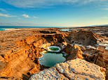
The Dead Sea, Jordan/Israel
This image shows sinkholes Ein Gedi in Israel caused by the retreat of the Dead Sea. According to Elborough, these threaten the stability of neighbouring roads and properties. He warns: ‘Only drastic action to replenish [the Dead Sea’s] waters will, in the end, avert something close to a catastrophe in the coming decades’
The Dead Sea has reached a ‘terminal phase’ in the past 50 years, Elborough explains in the book, as a result of the rivers that feed it being diverted for agriculture and into towns and cities.
He reveals: ‘Once 50 miles (80km) long, it currently stretches for barely 30 miles (48km) and its water levels are falling at a rate of one metre (three feet) a year.
‘What is at risk is not just a unique natural phenomenon that has defined an entire area for more than two millennia – a place that abounds with sites sacred to Jews, Christians and Muslims – but the whole of the surrounding ecosystem.
‘The retreat of the sea has produced a profusion of sinkholes, all threatening to undermine the neighbouring roads and properties. Only drastic action to replenish its waters will, in the end, avert something close to a catastrophe in the coming decades.’
Palenque, Mexico
To the right of this image is the Temple of the Foliated Cross at the ruined city of Palenque in south east Mexico. The book explains how this settlement was once a lost city
In the book, Elborough explains how Palenque in south-east Mexico was once a lost city.
The author reveals how it was one of the most important cities of the Mayan civilisation between the years of 250 and 900AD, but it had been ravaged by tribal warfare, failing agriculture and population decline by 950 and was gradually ‘absorbed by the surrounding jungle’.
Elborough continues: ‘This lost city would not be found again until the 16th century, when a Spanish priest Father Pedro Lorenzo de la Nada stumbled upon it with the help of a native guide during an exploration of the area.’
Leptis Magna, Libya
Pictured is the Arch of the Roman Emperor Septimius Severus at Leptis Magna in Libya, once one of the finest cities in the Roman Empire
Leptis Magna began life, Elborough explains, as a Phoenician trading post in 7 BC and went on to become ‘one of the finest cities in the Roman Empire’ until a series of earthquakes and raids left it as a ‘shrunken husk of its former self’.
The book goes on to explain that the city was abandoned by 643AD and how it ‘slumbered on until the Victorian era’ before a series of digs in the 1960s revealed the ‘full extent of its architectural treasures’.
The country’s political situation and the dictatorial regime of Muammar Gaddafi in the 1970s then served to ‘remove Leptis Magna from the view of the world at large’, Elborough notes, lamenting that while ‘perhaps easier to reach since Gaddafi’s death in 2011… most western governments advise against travel to Libya’.
Xanadu, Mongolia/China
This image showcases reliefs and the statue of Kubla Khan, grandson of Genghis Khan, in the ruins of the former Mongolian city of Xanadu. Elborough explains how this city was once lost but is now a ‘wonder’ of an archaeological site
‘The story of Xanadu, or what most of us think we know about this one-time capital of Mongol-ruled China, feels like an extended game of Chinese whispers, with unreliable accounts, and accounts of unreliable accounts, pilling up over the centuries since its creation,’ Elborough writes.
However, the writer goes on to confirm that the 13th-century city, which was ruled by Kubla Khan, grandson of Genghis, was once a 96-square-mile (25,000 hectare) metropolis filled with gardens, temples and government buildings, and ‘welcomed emissaries and merchants from across the globe’.
The author goes on to explain how Xanadu fell into ruin in the 14th century but was excavated in the 1990s and opened to the public in 2011.
Elborough concludes: ‘The ruins are a wonder. And a museum where hundreds of artefacts are displayed, carefully removed after centuries below ground, gives a sense of what has been lost. But arguably it still takes a slight leap of the imagination to picture what Xanadu must have been like in its prime.’
Skara Brae, Orkney
Pictured is the Neolithic settlement of Skara Brae on Orkney. Elborough warns: ‘The weather poses an ever-present danger to Skara Brae. Rising sea levels and increasingly violent storms connected to climate change could now wipe it away just as swiftly as the winds that unearthed it’
The story of prehistoric Skara Brae in Orkney is vividly depicted by Elborough.
He writes: ‘For centuries, the village had lain completely buried under a sandy mound known as Skara Brae. But its long slumber came to end one stormy night in February 1850. That evening, galeforce winds and the raging waves of the Atlantic swept along the western shoreline, causing the sand bank to collapse, ripping turf off the upper knoll and generally leaving gaping holes where there was once solid ground.
‘In this instant, part of the island’s Stone Age past abruptly broke into a Victorian steam-driven present, as sections of Neolithic dwellings were left poking out into the air.’
But Elborough warns: ‘The weather poses an ever-present danger to Skara Brae. Rising sea levels and increasingly violent storms connected to climate change could now wipe it away just as swiftly as the winds that unearthed it all those years ago.’
Roanoke, North Carolina, USA
This illustration depicts the island of Roanoke, which Elborough reveals was ‘England’s first serious stab at creating a colony in the New World of North America’. It is located in modern-day North Carolina, but the exact location is contested
The chapter on the island of Roanoke, located in modern-day North Carolina, begins: ‘Since its founding governor John White was an artist and cartographer who left charts of the territory, delicately sketched in watercolour, you might think finding Roanoke would be easy.
‘Yet the precise location of England’s first serious stab at creating a colony in the New World of North America continues to be contested, and what befell its inhabitants after 1587 is an even greater mystery.’
Roanoke, we learn, was first settled with permission from Queen Elizabeth I in the late 1570s, but the first settlers – more than 100 men and women – vanished. As to why, Elborough adds: ‘Multiple theories, many of them lurid, have been posited and these run the gamut from murder or abduction by native American tribes or slaughter at the hands of Spanish conquistadors to the whole colony being wiped out by an epic tidal wave. Gentler accounts have them assimilating into Native American communities.’
Petra, Jordan
Pictured is the monastery at Petra in Jordan. Elborough says the city was ‘lost to the world for close to a thousand years’
Petra – once the ‘epicentre’ of Nabatean culture and subsequently a thriving Roman and then Byzantine city – was ‘lost to the world for close to a thousand years’, says Elborough.
The author reveals how the conquest of the Byzantine Roman states of Syria, Palestine and Lebanon by Islamic forces in 636AD and the eventual establishment of Baghdad as the new capital of the Muslim world diminished Petra’s significance and ultimately led to ‘dusty abandonment and ruination’ until its rediscovery in the 19th century.
Today, Elborough notes that discoveries are still being made at the now world-famous 2,000-year-old site in modern-day Jordan.
He writes: ‘Even though Petra has had to contend with being in a location troubled by political and religious tensions for many decades now, it remains that endlessly fascinating “rose-red city half as old as time”.’
Port Royal, Jamaica
The above map of the harbours in Port Royal and Kingston dates back to around 1756, after Port Royal was destroyed by a series of natural disasters
In the late 17th century, Port Royal on the south-east coast of Jamaica was the ‘roistering capital of the Caribbean’, according to Elborough.
He writes: ‘The town was a freebooter’s paradise, a British-run Caribbean hot spot where pox-ridden and sunstroke-touched buccaneers could legally offload the loot plundered from Spanish galleons, and then avail themselves of the taverns and brothels that reputedly made up a quarter of all the premises.’
However, according to the author, all this was to change in 1692 when a series of natural disasters transformed the town beyond recognition – a sweeping fire, a hurricane and an earthquake that reduced the town to a mere 100 square metres (1,076 square ft).
On the topic of Port Royal today, Elborough writes: ‘Out beyond the bay and not far below the surface of the sea lie the streets and buildings where pirates got blind drunk on pipes of wine, often spending as much as 3,000 pieces of eight in a night.
‘Beyond that, too, in the murk and mud of the ocean bed, are estimated to be the largest single collection of wrecks in the world.’
The Everglades, Florida
The mangroves of the Everglades are retreating from the coast at a rate of 30m (100ft) per year, explains Elborough
The 1.5million-acre Everglades is a prized area of wetland in Florida, but it ‘teeters on the brink of extinction’, according to Elborough, with saltwater encroachment causing the retreat of its marshes.
He writes: ‘The mangroves, those areas of coastal vegetation that grow in the brackish water, which also serve as habitats for an array of different creatures, have been heading further and further inland, retreating at a rate of 30m (100ft) per year on what has been called a “death march” to escape the swelling ocean.’
On top of this, Elborough reveals that fertilisers and what he calls a ‘phalanx’ of invasive non-indigenous plant and animal species – including Burmese pythons that are descended from escaped pets – are attacking the Everglades’ fragile ecosystem.
The author concludes solemnly that only drastic action will save the famous wetlands.
River Fleet, London
This illustration depicts London’s Fleet River flowing in front of Bridewell Palace. Today the river in the capital is subterranean
According to Elborough, the River Fleet once flowed over ground in London from ‘the boggy, malarial marshlands of Hampstead’, through Kentish Town, Camden, King’s Cross and Clerkenwell before joining the Thames at Blackfriars.
The author explains how the Fleet was never the most attractive of waterways. He describes how, in the time of Henry III, it was little more than an open sewer, how 14th-century butchers used to toss entrails into it, and how in 1652 it was so clogged with rubbish it was almost impassable by boat.
Finally, the book reveals how the river was diverted underground in 1830 and turned into a sewer.
Slims River, Yukon, Canada
The Slims River (pictured) in Canada disappeared in 2016 in just four days. The chances of it returning to its former glory are unlikely
In 2016 the 300-year-old Slims River in Canada disappeared in just four days, Elborough reveals.
The author describes the cause an act of river piracy – a phenomenon that sees one river, in effect, steal the headwaters of another.
Elborough explains how the ‘shocking’ event was the result of the Kaskawulsh glacier, which used to sustain the Slims, melting faster and retreating further than ever before.
The author reveals: ‘Its retreat altered the gradient of the meltwaters, diverting their course south to nourish the nearby Kaskawulsh river into the Gulf of Alaska, and away from the Slims.’
According to Elborough, the chances of the Slims River ever returning to its former glory are unlikely.
The Congo Basin rainforest
Deforestation is rife in the Congo Basin Rainforest, which could disappear altogether by 2100. In this image huge chunks of mahogany are loaded onto trucks
The Congo Basin Rainforest is twice the size of France, but it could be all gone by 2100, Elborough warns, such is the rate of deforestation.
In the past 15 years alone, an area the size of Bangladesh has been destroyed.
He concludes: ‘Since the forest is estimated to be the fourth-largest carbon reservoir in the world and plays a vital role in regulating the globe’s climate, its fate should concern us all, and deeply.’
River Danube, Europe
According to Elborough ‘the eastern end of the Danube remains heavily at risk from a future ecological disaster’. Pictured above is the Danube in Vienna
‘The eastern end of the Danube remains heavily at risk from a future ecological disaster,’ Elborough writes.
According to the author, this is because unprotected pools of heavy metals and toxic sludge have been identified in defunct plants and reservoirs near the river in Hungary, Serbia and Romania.
Elborough adds: ‘The legacy of heavy industries such as bauxite and uranium mining, promoted by the regimes of the Soviet bloc, they threaten to leak into [the Danube’s] waterway with potentially devastating consequences for the river basin as a whole.’
Atlas of Vanishing Places – The Lost Worlds As They Were And As They Are Today, by Travis Elborough and with maps by Martin Brown, is out now (£9.99, Aurum Press)
Source link
CHECK OUT: Top Travel Destinations
READ MORE: Travel News