Historical maps reveal how North America’s sprawling cities have grown over the last one hundred and fifty years, expanding outward and upward through gold rushes and economic depressions – with some cities even building over rivers with man-made islands.
These incredible late 19th century maps offer a glimpse into the urban landscape of America post-Civil War, after 1865, when New York had a population of around one million (now eight times that) over 36 square miles and was yet to have wide spread electricity.
These full-color illustrations depict some of America’s greatest cities including Los Angeles, Boston, and the US capital, Washington DC, as they grappled with city engineering and built public infrastructure.
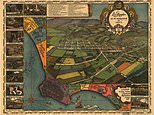
The nation’s capital, Washington DC, in 1892 featuring the famous Washington Monument – then only eight years old. The map also displays the proposed site of the 1892 World’s Exposition – a world’s fair celebrating technological progress
In contrast to the above 1892 map, today’s Washington D.C. features East Potomac Golf Course (left) on what once was a strip of partially submerged land, built up using material drudged from the river
One map offers a glimpse into the nation’s capital, Washington DC, in 1892 featuring the famous Washington Monument – then only eight years old.
The map also displays the proposed site of the 1892 World’s Exposition – a world’s fair celebrating technological progress and industrial development. The event was eventually held in Chicago.
Another map shows an already sprawling New York City in 1883, just one year after Thomas Edison’s Pearl Street Station in began generating electricity to supply 400 street lamps and 85 customers with electrical power.
Now containing 486 subway stations and 660 miles of subway track weaving underground the city is much more easily navigated, the first subway did not open until 1904, 21 years after this map was illustrated.
Thomas Edison’s Pearl Street Station in New York City began generating electricity to supply 400 street lamps and 85 customers with electrical power on September 4, 1882 – one year before this map was illustrated
Now containing 486 subway stations and 660 miles of subway track weaving underground the city is much more easily navigated, the first subway did not open until 1904. New York City pictured in 2020. The Dutch first established New York in 1624 as the colony of New Amsterdam on Manhattan Island – this later became New York City after the English took over
In the year of 1883 the Brooklyn Bridge was built, bringing the two cities of Brooklyn and New York together and seeing a boom in population.
And a rural-looking Los Angeles is seen in 1871 before the building of the 1885 Santa Fe railroad line – the city on the very precipice of industrial expansion.
While San Francisco is pictured in 1847 as a bay where whaling ships came to moor, before the Gold Rush of 1848 saw its population boom from 800 to 25,00 in just one year.
In 1843, American Inventor, Richard March Hoe, built the first rotary press inching the USA closer to achieving mass print production.
However, it took until the early 1900s for illustrations to become a staple of magazines and other print publications. As such, these full-colour maps were – and still continue to be – a rarity.
At the turn of the 20th century, more than 100 breweries were operating in St. Louis, including Anheuser- Busch – now the world’s largest brewer. Pictured: Saint Louis, Missouri in 1896. The city was founded by the French in Spanish territory in 1764
Saint Louis, Missouri, pictured today. The Gateway Arch (centre), the world’s tallest arch, was built in 1965 and dedicated to ‘the American people’. French fur traders Pierre Laclede and Auguste Chouteau founded St. Louis, and named it after Louis IX of France
This map shows Los Angeles, now one of the the U.S.’s most populated cities, in 1871, just 90 years after it was established in 1781 – the building of the 1885 Santa Fe railroad line saw a rapid industrial expansion
Where ranches were once farmed now 3.9 million people reside. The growing city began to rely on water from Owens Lake in Sierra Nevada in 1913 when an aqueduct that would transport water from the lake all the way to Los Angeles’ San Fernando Reservoir in Sylmar was built. Los Angeles pictured in 2020
Bangor, Maine, in 1875, was established in 1834 to provide for the lumber and shipbuilding industries as logs were easily transported along the river from the Main North Woods to be processed in the city before being shipped 30 miles downstream into the Atlantic Ocean for trade around the world – it was a world famous port
Pictured: Bangor, Maine, 2020. Now the city now surrounds services, retail and healthcare. In the late 1800s Bangor saw a decline in its lumber industries as companies moved to Michigan and Wisconsin, where new lumber was being cut
Pictured: San Francisco in 1847. In the early 19th century whaling ships and traders came to the bay, the town only had a population of 800. The town was established in 1776 and became popular after news that gold had been found there reached New York in 1848 (a year after the map illustrated above). Thousands flocked to San Francisco, with the population reaching 25,000 just one year late in 1849
The metro area of San Francisco now has a population of around three million. The Golden Gate straight which connects San Francisco Bay with Pacific Ocean is spanned by the Golden Gate Bridge (left) built in 1933
Pictured: Philadelphia in 1876. Philadelphia was established by William Penn, from London, with a few hundred people in 1683. The Independence Hall where the declaration of independence would be signed in 1776 was not built until 1732. Penn planned for Philadelphia to be grid-like, making it easier to navigate than London where he was from
Today Philadelphia is home to around five million people, it is known for its rich history, and has a strong tourist sector. With many visiting to see the Liberty Bell and Independence Hall
Barre, Vermont, in 1891. Barre is the most populous city in Washington County, Vermont, but it has not always been – There were 2,012 residents in 1830 and just 2,060 in 1880 as the city saw a slow growth. Due to a vast deposit of granite the area became populated with people from the granite industry
Cripple Creak in 1896. Cowboy Bob Womack first drew attention to the area in 1890 when he discovered the precious metal in Poverty Gulch, now known as Cripple Creek, Colorado. The town only had 600 residents in 1990s but was revived by the legalization of gambling in 1991
Boston, Massachusetts, in 1873. The city was established in 1630 by English Puritans fleeing religious persecution. In 1706 Founding Father of the United States Benjamin Franklin was born in Boston. By 1730 Boston had a population of more than 13,000
As Boston grew large amounts of land were gained by filling small areas of water with land, note fewer bodies of inland water visible in today’s Boston (pictured). The population of Boston now stands at around 600,000
Source link
CHECK OUT: Top Travel Destinations
READ MORE: Travel News