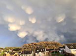
Stunning ‘mammatus’ clouds that look like UFOs have appeared in the sky above Glasgow following severe weather warning for high winds from Storm Dudley.
These unique formations might be mistaken for spaceships or clouds but they are actually a unique weather event known as mammatus.
They are some of the ‘most unusual and distinctive’ types of clouds formations, according to the Met Office.
The weather service says turbulence forms these new clouds out of dense, towering storms that people see during thunderstorms, tornadoes and hailstones.
Instead of moving upwards like other clouds, mammatus move down, making the bottom of the cloud look uneven.
Shapes of these clouds vary widely and can have a protruding shape, to a more elongated tube hanging from the cloud above.
Pictures below show the incredible moment that Kenneth Mooney, 39, from Glasgow, captured the images of these rare clouds.
Kenneth Mooney, 39, noticed dark clouds forming above his Newton Mearns, Glasgow home in Scotland when he grabbed his camera and took pictures of the white round clouds that appear to be moving down
The clouds look round like fluffy UFOs but they are actually a unique weather event. Mammatus clouds are some of the most unusual and distinctive clouds formations with a series of bulges or pouches emerging from the base of a cloud, according to the Met Office
Round in shape the clouds appear to be hovering over these Glasgow homes looking like UFOs ready to descend and invade at any moment but the bundles of air will not as they are a rare and stunning cloud
What are mammatus ‘UFO’ clouds?
Mammatus clouds are some of the ‘most unusual and distinctive cloud formations’ according to the Met Office.
What are mammatus clouds?
Mammatus clouds have lots of bulges or pouches that come from the bottom of a cloud.
The shape of mammatus formations can vary widely; from the classic protruding shape, to a more elongated tube hanging from the cloud above.
How do mammatus clouds form?
Turbulence causes the new clouds to form out of large, dense, towering storm formations known as cumulonimbus clouds that people see during thunderstorms, tornadoes and hailstones.
Mammatus forms out of the ‘projecting anvil’ from the cumulonimbus as it heads downwards.
Instead of moving upwards like other clouds, mammatus move down, making the bottom of the cloud look uneven.
Sometimes mammatus may form on other cloud types which produce no rain, though this is far less common.
What weather is associated with mammatus clouds?
Mammatus cloud generally form in the most unstable cumulonimbus, meaning that there is also a chance of hail, heavy rain and lightning in the vicinity, and if the air is cold enough during winter they can produce snow.
Sometimes mammatus may form on other cloud types which produce no rain, though this is far less common.
What does mammatus mean?
It comes from the Latin mamma which translates to ‘udder’ or ‘breast’.
When is best to see them?
Their striking appearance is most visible when the sun is low in the sky and their pouches are framed by the sunlight after a heavy bout of storms.
Their odd nature makes them a huge hit with meteorologists as well as cloud and photography enthusiasts.
Source: Met Office
Kenneth, a postman, who took these pictures during a severe weather warning, described the clouds as like a ‘spaceship or like the inside of a lava lamp’ due to their uneven bases that look out of this world
The postman from Newton Mearns was on the lookout for any damaging winds in his area at 4.30pm after being alerted to Storm Dudley on Wednesday when he noticed the incredible mammatus clouds.
He described the clouds as like a ‘spaceship or a lava lamp’ due to their uneven bases that look out of this world.
Kenneth said: ‘I suppose you could describe the clouds like a spaceship or like the inside of a lava lamp as that’s a bit more sanitised
‘I had been keeping an eye out the window to look at the trees across the road to see how bad it was getting.
‘When I noticed the sky had got dark to the north while the sun was still out in the south.
‘I thought it was the perfect situation for a rainbow when I noticed these clouds beginning to form.
‘They were travelling quickly from South-west to North-east.
‘I believe they form when cold air sinks rapidly within a cumulonimbus (storm) cloud.
‘I posted them on a cloud appreciation page on Facebook, and the likes are ticking on as we speak!’
Mammatus often forms in association with Cumulonimbus clouds, which in turn bring thunderstorms due to their huge mass of unstable air. Mammatus cloud generally form in the most unstable cumulonimbus, meaning that there is also a chance of hail, heavy rain and lightning in the vicinity, and if the air is cold enough during winter they can produce snow
Sometimes mammatus may form on other cloud types which produce no rain, though this is far less common. Their striking appearance is most visible when the sun is low in the sky and their pouches are framed by the sunlight after a heavy bout of storms
Mammatus comes from the Latin mamma which translates to ‘udder’ or ‘breast’. The clouds have uneven bases that are pushing downward from the sky, and almost onto the houses, the opposite of what people would typically see from normal clouds
But the beauty of the clouds are not without danger as the series of storms Britain has been having continued to cause issues throughout the country.
Following days of disruption due to Storms Dudley last Wednesday, who caused the Mammatus clouds, and Eunice last Friday, up to 33,000 homes remained without power today.
Storm Franklin swept in overnight with a Met Office yellow wind warning in place for England, Wales, Northern Ireland and western Scotland until 1pm this afternoon as electricity engineers battle to reconnect properties.
More than 450 flood alerts or warnings were in place across the UK, including two severe warnings in south Manchester that prompted more than 400 homes to be evacuated – while Northern Ireland was also badly hit.
Train operators again warned customers to ‘avoid travel’ or ‘do not travel’ with services paralysed by gale-force winds and lashing rain.
Source link
CHECK OUT: Top Travel Destinations
READ MORE: Travel News