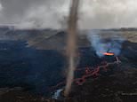
Iceland’s newest volcano continues to put on a spectacular display, with a ‘tornado’ spewing out of its crater.
New footage shows the twirling air column emanating from Litli-Hrútur, or ‘Little Ram’ volcano, which formed last month in Iceland’s Reykjanes peninsula.
The stunning spectacle is the result of heat from lava warming up the air above it, making the air less dense and causing it to rise.
Under the right wind conditions, this column of hot air starts to spin like a super-fast corkscrew and appear like a ‘tornado’.
Litli-Hrútur has already been throwing ‘spatter bombs’ of molten lava into the air and landing well beyond the rims of the crater.
The new footage shows the long twirling mist emanating from Litli-Hrútur, or ‘Little Ram’ volcano, in Iceland’s Reykjanes peninsula
David Smart, a storm researcher at University College London, said the term ‘tornado’ can be used in this case, even though it’s likely different from the traditional definition of a tornado.
The American Meteorological Society defines a tornado as a rapidly rotating column of air extending vertically from Earth’s surface to the base of a cumulus cloud.
This ‘tornado’ appears to be connected to a different cloud altogether – the cloud of ash emitted by the volcano (known as the ‘eruption column’).
‘It’s not clear from the video whether the vortex is in fact from the eruption column cloud,’ Smart told MailOnline.
‘I think it likely that it was an atmospheric instability near the surface enhanced the updraught in the lowest cloud layer and beneath the eruption cloud.
‘This effect “stretches” the vorticity (“spin” of air parcels) near the ground and leads to a tall, compact vortex.’
Lovísa Mjöll Guðmundsdóttir, a specialist in natural hazards at the Icelandic Metrological Office, said it can be more accurately referred to as a ‘dust devil’.
‘A dust devil forms when a pocket of hot air near the surface rises quickly through cooler air above it, forming an updraft,’ she told MailOnline.
The volcano, which is located on Mount Fagradalsfjall, began erupting on Monday following heightened seismic activity in the area. It is located 20 miles from the Keflavik airport
The stunning tornado or ‘dust devil’ is the result of heat from lava warming up the air above it, making the air less dense and causing it to rise
Under Iceland’s cascading winds, this column of hot air spins like a corkscrew to produce the ‘tornado’
Litli-Hrútur has already been throwing ‘spatter bombs’ of molten lava into the air and landing well beyond the rims of the crater
Timeline of the volcano’s formation
July 4: Increased seismic activity in Iceland’s Reykjanes peninsula
July 10: An underground eruption opens a 1.7-mile-long fissure in the ground
July 18: ‘A major shift in the vent activity’ of the volcano causes lava to ‘fill up to the brim’
July 19: Lava spills over the crater and the crater collapses
Litli-Hrútur was formed when an underground eruption opened up a 1.7-mile fissure in Iceland’s Reykjanes peninsula, which is south-west of capital Reykjavík and close to the country’s primary international airport, Keflavik.
This underground eruption was preceded by a ‘seismic swarm’ of 7,000 earthquakes in the region, the largest of which was a magnitude 4.8 quake, according to the Icelandic Met Office.
There are usually earthquakes leading up to a volcanic eruption, caused by the movement of magma and other fluids within the volcano.
According to the Icelandic Met Office, pockets of methane within the lava are also exploding, a leading to loud bangs audible to locals.
‘When lava flows over a vegetated area, methane gas can be produced when the vegetation does not burn completely,’ it said in a Facebook post.
‘The gas then accumulates in gaps and cavities in the lava.
‘It mixes with oxygen, and when an ember or flame from the fire breaks out into it, an explosion occurs.’
Scientists said the temperature of the lava seeping from the crater was about 2,192°F (1,200°C).
Ingibjörg Jónsdóttir, an associate professor of geography at the University of Iceland, said there had been some ‘concern’ because two people had been in the area just over an hour before the crater collapsed.
‘There is no way they would have had time to escape and survive it they had been there an hour later, since the collapse happened so quickly,’ she told MailOnline.
Litli-Hrútur is part of the Fagradalsfjall volcanic area, located in an uninhabited part of the Reykjanes peninsula
‘They should of course not have been there since the area so close to the crater is closed and extremely dangerous.’
Authorities in Iceland warned spectators to stay away from a newly erupting volcano that is spewing lava and noxious gases.
The Icelandic Met Office has said locals should ‘beware of this danger and not to go too close to the edge of the lava’.
Still, tourists and spectators are flocking to the site, eager to witness the natural spectacle up close.
One British YouTuber headed to the active volcano to cook a shop-bought chicken curry, but activity at the site could be on the decline.
Last week, Litli-Hrútur produced somewhere between 30 and 50 per cent less lava than the previous week, RÚV reports.
This indicates the end of the eruption could be only one to two weeks away, according to Þorvaldur Þórðarson, professor of volcanology at the University of Iceland.
‘Based on how the changes have been in the last week, it would be one to two weeks until the end of the eruption, maybe it could take a little longer.’
Last week, European Space Agency (ESA) has released a satellite image of the volcano erupting, appearing as a orange blob on the Reykjanes peninsula trailed by a smoke plume.
European Space Agency has released a satellite image of the volcano erupting, appearing as a orange blob on the Reykjanes peninsula trailed by a smoke plume
This aerial photo taken on July 10 shows smoke billowing from flowing lava during a volcanic eruption
Authorities in Iceland warned spectators to stay away from a newly erupting volcano that is spewing lava and noxious gases
Satellites orbiting above are continuously capturing the molten lava and smoke plume puffing from the ”Little Ram’.
‘Satellite technologies now make it possible to monitor volcanic activity in even the most isolated corners of the globe,’ the ESA said.
‘Satellites carry different instruments that provide a wealth of complementary information to better understand volcanic eruptions.’
Litli-Hrútur is part of the Fagradalsfjall volcanic area, which, after around 800 years of silence, burst into life in March 2021 with an eruption in the Geldingadalur valley followed by a smaller eruption in the nearby Meradalur valley in August 2022.
HOW CAN RESEARCHERS PREDICT VOLCANIC ERUPTIONS?
According to Eric Dunham, an associate professor of Stanford University’s School of Earth, energy and Environmental Sciences, ‘Volcanoes are complicated and there is currently no universally applicable means of predicting eruption. In all likelihood, there never will be.’
However, there are indicators of increased volcanic activity, which researchers can use to help predict volcanic eruptions.
Researchers can track indicators such as:
Volcanic infrasound: When the lava lake rises up in the crater of an open vent volcano, a sign of a potential eruption, the pitch or frequency of the sounds generated by the magma tends to increase.Seismic activity: Ahead of an eruption, seismic activity in the form of small earthquakes and tremors almost always increases as magma moves through the volcano’s ‘plumbing system’.Gas emissions: As magma nears the surface and pressure decreases, gases escape. Sulfur dioxide is one of the main components of volcanic gases, and increasing amounts of it are a sign of increasing amounts of magma near the surface of a volcano. Ground deformation: Changes to a volcano’s ground surface (volcano deformation) appear as swelling, sinking, or cracking, which can be caused by magma, gas, or other fluids (usually water) moving underground or by movements in the Earth’s crust due to motion along fault lines. Swelling of a volcano cans signal that magma has accumulated near the surface.
Source: United States Geological Survey
Source link
CHECK OUT: Top Travel Destinations
READ MORE: Travel News